


SPC Mesoscale Discussion
SPC MD 558
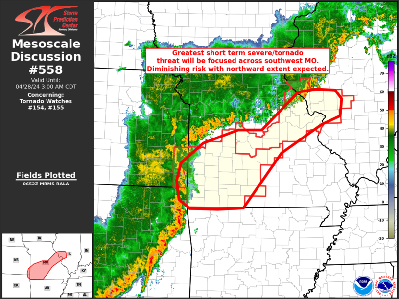
MD 0558 CONCERNING TORNADO WATCH 154...155... FOR PORTIONS OF MO INTO WEST-CENTRAL IL
Mesoscale Discussion 0558
NWS Storm Prediction Center Norman OK
0154 AM CDT Sun Apr 28 2024

Areas affected...portions of MO into west-central IL

Concerning...Tornado Watch 154...155...

Valid 280654Z - 280800Z

The severe weather threat for Tornado Watch 154, 155 continues.

SUMMARY...Greatest severe potential is expected across southwest
Missouri in the short term. Overall risk is diminishing with
northward extent.

DISCUSSION...Outflow associated with convection across central MO
into west-central IL is outpacing convection over the past hour or
two. This, coupled with increasing low-level
inhibition/boundary-layer stabilization is largely limiting severe
potential. As a result, Tornado Watch 154 will be cancelled early
per collaboration with WFO LSX.

Further southwest, a more mature/organized QLCS over northeast OK
will spread into southwest MO. While weak low-level inhibition is
present, stronger ascent and more favorable low-level shear may
still support a tornado and damaging wind risk over the next couple
of hours, especially across southern portions of Tornado Watch 155.

..Leitman.. 04/28/2024

...Please see www.spc.noaa.gov for graphic product...

ATTN...WFO...ILX...LSX...LZK...SGF...EAX...TSA...

LAT...LON   36469452 36689488 37189497 37649484 38169413 38519299
            38519220 39489099 39549039 39518976 39288954 38838961
            38639023 37919157 36489280 36459363 36469452
Read more